
 English
1Institute of International Training and Cooperation, Hanoi Architectural University, Hanoi 12109, Vietnam
2UMR Eco&Sols, IRD, CIRAD, INRAe, SupAgro Montpellier, 34060 Montpellier, France
*
Author to whom correspondence should be addressed.
Water 2023, 15(15), 2712; https://doi.org/10.3390/w15152712
Received: 19 June 2023 / Revised: 18 July 2023 / Accepted: 21 July 2023 / Published: 27 July 2023
(This article belongs to the Special Issue Waste Water Used for Green Production in Cities)
https://www.mdpi.com/2073-4441/15/15/2712?fbclid=IwAR0LfdVH2w5hC77SOyeyR2wTSzb4sEWulZH-Ac-x8mJV1-z_9UulM_dPYUQ
Abstract
Public gardens in urban areas play an important role in the development of physical and mental health of the people. These spaces are also social spaces, where people meet to interact, exchange, and organize collective activities. They create a unique identity for each residential area in the city, which is a premise for green urban development. In Hanoi, public flower gardens (PFGs) were formed and developed from the French colonial period, mainly those in the historic city centre. Facing the forceful urbanization process and the changing of urban structure, in order to evaluate the role of all public flower gardens in the historic city centre area, we carried out a systematic survey from 2019 to 2022. We surveyed all 30 PFGs in five central districts of Hanoi, and interviewed 229 users at these gardens. We also conducted research on relevant documents regarding the management and planning of green space and water infrastructure in the city. Moreover, we implemented an experimental workshop, combining an urban living lab (ULL) approach and an in situ landscape approach, to develop urban landscape design ideas with community participation. Based on the data from this research, this paper analyzes the potential for the establishment of urban blue-green infrastructure (BGI) from these PFGs and aims to evaluate the role of community participation in landscape design for the city. Data from multiple collection methods provide a multi-faceted understanding of the original characteristics of the PFGs in Hanoi and their importance in urban life. The project results supply experimental lessons from urban landscape design activities through community participation, which opens up the potential for developing sustainable urban spaces based on existing natural structures in the city. The main result proves that active community participation until the end of the research project raises public awareness and ensures the social acceptance of the final design. These lessons allow the improvement of urban landscape design practices and the establishment of BGIs from PFGs in an efficient and sustainable manner for green cities in the future.
1. Introduction
Sustainability is becoming a must for the development of cities, especially in the context of increasing impacts from climate change and biodiversity loss, which are the two limits that have been crossed out of the nine boundaries for the sustainability of the earth [1]. However, urban areas face a dilemma when consumption demand and population increase, while space, infrastructures, and resources are decreasing [2,3]. The Smart City is a concept that has received a lot of attention recently, taking advantage of information and communication technology [4]. But “first generation Smart City projects, strategies and academic literature has a rather technological-deterministic or techno-optimistic point of view” [5], while a sustainable city needs more than just “smart” technology because it is a life-containing environment characterized by the interaction between people, other living creatures, and infrastructures, both natural and artificial. Thus, tackling sustainability in urban environments requires “better understanding of the multiple ways the developing science of cities can be incorporated into the planning, design and management of cities to activate the systems approach to the urban future“ [3]. In reality, a city, despite being a highly anthropized environment, is fundamentally still a component of the global biome, interacting with other “natural” components, and even itself can be considered as an ecosystem, comprising both artificial and natural elements interacting with each other [6,7]. The sciences of ecology and of the landscape, transcending their original traditional limits, can become the key to smart, efficient, yet simple and low-consumption solutions [8,9,10]. For example, many social challenges can be addressed through nature-based solutions, which is a direction that is being promoted worldwide [10,11]. The establishment of urban Blue-Green Infrastructures (BGI), which can be accomplished by leveraging available blue and green spaces in cities, is one way of realizing this strategy. These infrastructures have been argued to be able to offer “environmental, economic and social benefits” [12]. On the other hand, since cities are run by multiple stakeholders, several studies suggest that sustainable development as well as the application of BGI to urban design and planning requires a participatory approach that involves the joint efforts of socio-economic enablers and places’ users [12,13,14,15].
First mentioned at the end of the 1990s by computer science scholars [16], the concept of the living lab concerned only user-driven, human-centered, and participatory approaches to design challenges. The recent attention for living labs in urban environments comes from the fact that within living labs, collaboration happens in a real-life setting, and expected outcomes (e.g., products, processes, learning) emerge within the participants’ daily life [17]. A living lab could be a physical or virtual space in which to solve societal challenges, especially for urban areas, by bringing together various stakeholders for collaboration and collective ideation [18]. The urban living lab is an urban design approach with community participation which was studied [19,20,21,22,23,24,25,26,27] and recently experimented in Vietnam [28,29,30,31]. The urban living lab (ULL) has been mentioned as a way to manage innovation processes in an open, inclusive, and collaborative approach, in which innovations are developed by engaging different stakeholders, including the community. This approach also promotes experimentally interdisciplinary integration in urban planning through field studies and exchanges, where participants are encouraged to innovate and to be creative in a realistic context. ULLs stimulate processes of reflection and questioning [32], facilitate discussions with the purpose of aligning and defining the possibility of action in a decision-making process [6], and may create changes that are valuable for a group of people and pressure existing regimes to broaden collaboration, engagement, and empowerment of citizens [17]. The city can benefit from practical and creative ideas based on contributions from the community, which are not always easy to implement and develop in urban planning projects because of lack of financial and human resources [30]. Moreover, cities can use ULLs to enable the systematic management of interactions between stakeholders and establish a link between top-down policy and bottom-up interactions. ULLs serve as collaborative ecosystems that foster the co-creation of sustainable and future-proof innovations, contributing to the improvement of urban life and the stimulation of economic growth [5]. In this sense, they are considered potential triggers of innovation in urban environments. It has been demonstrated that ULLs contribute significantly to the production of local knowledge in relation to the development of relational capital, which is of importance for experimentation with new practices, relationships, and governance arrangements.
Hanoi is a city with a high rate of urbanization over the past thirty years and currently faces many challenges for sustainable development. Public flower gardens (PFGs) have long played an important role in social and cultural life and have become an indispensable part of the green spaces network as well as of the urban structure of the city. For the city centre today, the presence of PFGs is not highlighted but they are always useful and attractive open spaces. These PFGs contribute not only to improving the city’s landscape, but are also important open spaces where cultural and entertainment activities take place and connect people. Until now, PFGs located in the historic city centre with a total area of 37 ha are being managed by the municipal authority [33]. Most of these gardens were created during the French colonial period and remain in their original form. With determination to build a “Green, Clean, Beautiful and Livable City” [33], Hanoi city aims to develop these PFGs as a multi-purpose solution to address pollution issues in the city centre and to improve the living conditions of the people.
The network of public gardens could therefore be a starting point for the establishment of a system of BGIs in urban areas of Hanoi, a concept of urban development that has received much attention in recent times thanks to the benefits it brings [12]. A research project on PFGs in the city centre of Hanoi ordered by the Department of Science and Technology, Hanoi People’s Committee, was conducted by experts from Hanoi Architectural University (HAU) from September 2020 to February 2022. Because community involvement is indeed a key factor in creating an innovative and sustainable landscape design for the city [34], the project has been conducted to clarify the role, value, and potential of these PFGs in improving environmental quality and developing green urban infrastructure for the city with community participation [35]. This project, titled “Assessment of the current situation and propose solutions to organize landscape architecture of PFGs in the historic city centre of Hanoi with the community participation”, has been carried out in five districts of Hanoi city centre: Ba Đình, Hoàn Kiếm, Đống Đa, Hai Bà Trưng and Tây Hồ, which represent 5860 ha and 1,269,100 inhabitants.
This paper proposes to analyze the data collected from the above research project to evaluate the PFGs in Hanoi’s historic centre as potential BGI elements to integrate for city urban planning. We aim to present how the ULL approach and landscape approach could be appropriate methodologies to explore the potential of establishing a BGI for a sustainable city where many stakeholders are involved in the development process. The paper is organized into four sections. In Section 1, we engage with the literature on the establishment and the integration of BGIs into urban planning by the landscape approach and community participation through the ULL approach. In Section 2, we describe the research project and the methodology used to conduct this paper. In Section 3, we categorize results from the landscape approach and ULL approach in two phases of the research project. In Section 4, we discuss our main findings in relationship with the sociocultural value of PFGs and the dynamics and emerging practices of citizens at PFGs in view of their wider implications for landscape design and city development.
2. Materials and Methods
2.1. The Research Project
The research project “Assessment of the current situation and propose solutions to organize landscape architecture of PFGs in the historic city centre of Hanoi with the community participation” consisted in two phases. The first phase aims to assess the actual state and preliminary potential of all the PFGs in five districts of Hanoi’s historic centre (Figure 1) through three main activities: spatial mapping, a sociological survey, and document analysis. In the second phase, a pilot urban design project was carried out at Thanh Niên PFG in the Tây Hồ district (Figure 1) to test a landscape design project with the community participation. This garden was chosen for its special blue-green features. It is the most important PFG among five PFGs located next to West Lake, the city’s largest and most iconic urban water body. The garden also offers a substantial green space for the city, which shows potential for establishing BGIs.
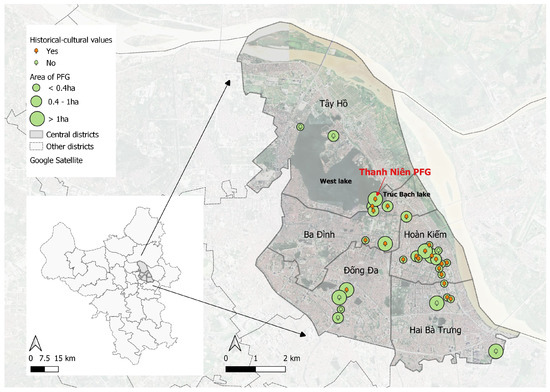
Figure 1. PFGs identified in five districts of Hanoi’s historic centre: Ba Đình, Đống Đa, Hoàn Kiếm, Tây Hồ, Hai Bà Trưng.
2.2. Methodology
2.2.1. Landscape Approach and ULL Approach
The research project adopted a combination of the landscape approach and the ULL approach.
-
About the landscape approach:
The landscape is not simply the physical land, but a concept that harmonizes the material and the spirit of the territory, seen through human perception. The landscape at each site shows us how the society and space are organized there. Firstly, landscape, which has been traditionally associated with gardening [9,36], has evolved into a multidisciplinary scientific field that includes not only art but also a multitude of scientific disciplines [9,36,37,38], “including ecology, geography, economics, anthropology, environmental sciences, spatial planning, and public administration” [36]. This approach stems from a broader definition of landscape, which is not just a spatial entity but also encompasses “economic, social, ideological, and psychological identities”, “shaped by both natural and sociopolitical processes, and it reflects a high multifunctionality, as it harbors both biodiversity and biocultural functions” [38]. This transformation has given landscape approaches an important role in the transition towards sustainable development [9,38], “which urges for cross-sectoral, multistakeholder, and policy integration approaches” [36].
Furthermore, while the approach has been updated, the core of landscape, which is a geography-based scientific discipline, remains unchanged [38]. “Landscape architecture is about site: without a locus (Latin for ‘place’), landscape architecture has no raison d’être” [36]. The association with a physical territory is also an advantage of the landscape approach when dealing with development issues because it allows working with specific issues [39] and solutions at various scales “from regional planning to detailed planning, urban design, public space design, technical infrastructure, landscapes, living spaces” [40], encompassing various entities such as “agricultural landscapes and forests”, “townscape”, and “parks and gardens” [36].
Therefore, the landscape approach helps to evaluate the territory from many angles: environmental, social, cultural, and even emotional [9]. An important requirement for the landscape approach is the attachment to the ground. Elements observed, discovered, and perceived on the field are an important basis for understanding as well as inspiration for the landscape design.
The landscape approach used in the research project is based on landscape identification and decoding (Figure 2), a method of evaluating and analyzing landscape space through its own characteristics [40]. The identification and decoding of landscape space help the designers to understand the structural components of a given space, and the relationship between these structural elements and the process of transforming space from the past to the present, thereby envisioning and proposing a future scenario for the designed landscape space. The purpose of spatial identification and decoding is also to build a future intervention method within the landscape based on the ability to recognize the current and future changing laws of the landscape.
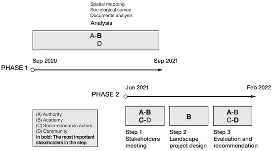
Figure 3. Framework of the research project.
-
Phase 1
During the first phase of the research project, three activities were carried out, including spatial mapping, a sociological survey, and document analysis. The members of the research team were divided into five groups, each group having 4–5 members, and undertook all PFGs in each district.
Spatial mapping and analysis were mainly based on the landscape approach. At each PFG, the team drew the current plans and cross-sections of the vegetation, traffic, and landscape lighting system operating in a few time frames (5–6 am, 5–7 pm, 8–11 pm). The team also systematically took pictures and plotted the featured spaces and activities. The objective was to have a good understanding of blue and green spaces and the activities, users, equipment, and services in each PFG.
The sociological survey was conducted on all the PFGs in five urban districts of Hanoi (Figure A1). A questionnaire including 40 questions was designed focusing on the following groups of information: (i) General information about PFG users; (ii) Purpose and personal use needs of PFGs in Hanoi; (iii) Assessment of the quality of space, trees, technical infrastructure, services, and management; (iv) Desire for the development of PFG space. The information from the interviews was used anonymously and for research purposes only. The initial goal was to conduct an average of 10 surveys per PFG. The target audience was all the people who use the PFG, including representatives of the local authority, tourists, and walkers.
Besides field study, document analysis was also applied. Documents collected and analyzed were satellite images, maps, historical documents, urban planning documents, laws, regulations, city strategy, etc.
-
Phase 2
In phase 2, a pilot design project was implemented at Thanh Niên PFG with the ULL approach through 3 steps, as follows:
Step 1—Stakeholder meeting
In the first step, all stakeholders involved in the pilot design project came together to discuss the results of the data collection in phase 1, and to develop a preliminary program for the urban design project of Thanh Niên PFG. There were four stakeholder groups identified by ULL approach. For the Authority group (A), we had the participation of the local People Committee’s representatives, including the cultural and urban management offices. The Academic group (B) was represented by experts and research teams from HAU. The Socio-economic group (C) was represented by a private company. Finally, the Community group (D) consisted of the Women’s Union, the representatives of the sub-quarter, the people living in the surrounding area, and users of the PFG.
Step 2—Landscape project design
In the second step, a design workshop for Thanh Niên PFG was held for one week. This design activity was carried out by three groups of architects who were part of HAU and were involved in all the activities from the beginning of the research project. Each group produced an urban landscape design proposal for the Thanh Niên PFG, based on data collected and analyzed from phase 1 and assessments during previous stakeholder meetings in step 1.
Step 3—Evaluation and recommendation
After the completion of three landscape design proposals, an exhibition was held to present them to the public. At the same time, a community survey was conducted in two ways: on-line and in person, with the participants at the event. The survey had three goals: (i) Collection of information on the purpose and community demand for Thanh Niên PFG space based on landscape design proposals; (ii) Evaluation and classification of three landscape design proposals; and (iii) Collection of community comments and ideas for the landscape design proposals. The feedback of the respondents was used as a basis for selecting the best design and finalizing the technical dossier, as well as for the recommendations delivered to the city.
3. Results
3.1. PFGs Mapping Data in Five Districts of Hanoi’s Historic Centre
The spatial mapping activity carried out in phase 1 of the research project resulted in a set of iconographic profiles of all the PFGs in the five central districts. For the first time, a PFGs mapping database was created. It is noteworthy that the implementation of data collection in phase 1 encountered many difficulties because the number of, and information on, PFGs in the five central districts of Hanoi in the official reports was not consistent. The survey results identified a total of 30 PFGs in the five central districts (Figure 1), of which Ba Đình and Đống Đa districts have 4 PFGs each, Hai Bà Trưng and Tây Hồ districts have 5 each, and Hoàn Kiếm district has 12 PFGs (Table A1).
Each PFG is described by a set of iconographic documents, including maps, photographs, plans, and sections, as follows (cf. Figure A2):
- –
-
A map of the locations of the PFGs in their respective districts: the document is rendered on a Google Maps background, where the district boundary and the location of the PFG are highlighted in color.
- –
-
A Master plan of PFG provides an overall view from above of the components and the spatial composition of the PFG in the surrounding urban context.
- –
-
The current state of the PFG’s vegetation is represented in two forms: photographs and cross-sections. The photos provide an overview of the different types of plants and planting methods used. The cross-sections illustrate the typical spatial composition of the planted areas within the PFG space. The number of photographs and sections varies depending on each specific situation.
- –
-
The current state of human activities at the PFG is represented in three forms: photographs, a plan (same scale as the Master plan), and cross-sections. The photos provide an overview of people’s typical activities, while the plan and cross-sections represent the position and distribution of these activities within the spatial structure of the PFG. The number of shots and cross-sections varies depending on each situation.
- –
-
Traffic in the PFG is described by a plan at the same scale as the Master plan. This document indicates the access to the PFE from surrounding areas and internal routes inside the PFG.
- –
-
The lighting system at the PFG is explained through a plan (same scale as the Master plan) and cross-sections, showing the number, location, and lighting form of light poles. The number of the cross-sections depends on situation of each PFG.
- –
-
Street furniture at the PFG, including urban equipment such as toilets, benches, billboards, etc., is integrally represented in the lighting system documents, depending on the situation of each PFG.
A comprehensive dataset has been established, including images and detailed drawings that describe not only technical information but also the operational and functional aspects of all PFGs at different time points throughout the day. These are characteristic results of the landscape approach when using specialized landscape architecture tools, such as drawings, to describe the spatial and temporal characteristics of a PFG. This dataset has helped all stakeholders to easily understand the features, nature, and operation of the PFGs. Additionally, it has facilitated exchanges, sharing, and consensus ideas among inhabitants, authorities, and professionals.
3.2. Sociological Survey
Another result from phase 1 of the research project was a sociological dataset on 30 PFGs in five central districts of Hanoi. The responses were collected from 234 respondents, in which 45% were female and 55% were male. The ages of the respondents was mainly from 23–60 years old (52%). The groups of people aged 14–22 and over 60 years old accounted for 14% and 34% of the participants, respectively.
3.3. Landscape Design Proposals
In phase 2, three landscape design ideas were proposed, titled: 1—Associated with the historical and cultural path; 2—Towards a sustainable ecosystem; 3—From Thanh Niên (Youth) to Thanh Long (Blue Dragon). In general, all design teams began work by analyzing the site in terms of landscape, history, culture, activities, and transformation, etc. They then proposed a landscape design concept and illustrated the implementation. Despite having a similar framework, each team had different priorities and personal perceptions during the analysis, leading to differences in outcomes.
The first design proposal, titled “Associated with the historical and cultural path”, focuses on analyzing issues such as urban transformation, the process of social change, cultural features, accessibility, and activities (Figure A3a). This proposal introduces the concept of an “Urban healing station” through creating private spaces, renovating the square space, increasing access to surface water, and specially designing business spaces.
The second design proposal, titled “Towards a sustainable ecosystem”, highlights issues such as urban transformation, the process of ecological change, and the sense of space, vegetation, and activities (Figure 4). This proposal suggests “Ecosystem regeneration”, which can be achieved through activities such as promoting cultural and historical values, designing to recreate the natural-human ecosystem, enhancing existing public spaces, creating space for the wetland ecosystem, increasing access between people and natural spaces through a system of walkways, and planting embankments.
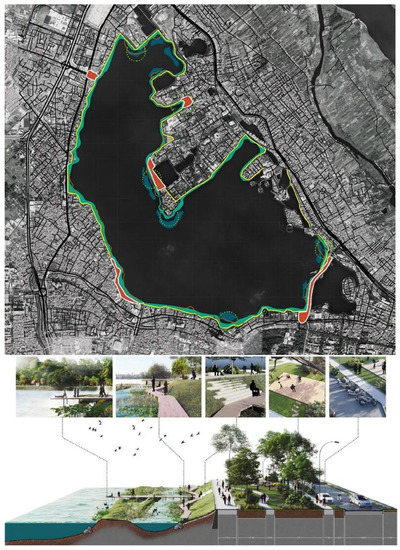
Figure 4. Ecological structure surrounding West Lake in landscape design proposal 2 (selected proposal by community).
Lastly, the third design proposal, titled “From Thanh Niên to Thanh Long”, focuses on themes such as cultural and historical values, tourism potential, economic value, infrastructure, and activities (Figure A3b). The standout concept of this proposal is a “Stage on the water”, which can help promote cultural and historical values, address space usage conflicts, and restructure and create spaces for human activities.
3.4. Community Participation in the Landscape Design Process
The evaluation and the selection of the best landscape design proposals were organized through community voting and surveys. A total of 102 questionnaires were collected from respondents, in which 82 were conducted on-line and 20 collected on-site during the exhibition event. At the end, design proposal number 2 was selected as the most satisfying to the public (Figure 5). It was later improved in the form of technical documents and submitted to the local authority.
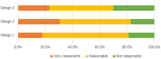
Figure 5. Community evaluation of three landscape design proposals for Thanh Niên PFG.
4. Discussion
4.1. Identification of Characteristics and Properties of the PFGs in Hanoi’s Historic Centre to Recognize Their Role
4.1.1. Significant Cultural–Historical Values of the PFGs
In the five central districts, 73% of the PFGs have high historical and cultural values, especially for the PFGs in the Hoàn Kiếm district, with 92%. This can be explained by the historical and heritage characteristics of the district, which encompasses a public space complex with Hoàn Kiếm Lake—the famous iconic lake of Hanoi—and other cultural and religious structures such as Turtle Tower, Ngọc Sơn Temple, etc. Other PFGs located next to important traditional religious monuments such as temples and pagodas have the same names as the heritage monuments, such as Quán Sứ PFG, Bà Kiệu PFG, etc. These PFGs are clearly not only important public open spaces to improve the living environment for urban residents, but also ambassadors to communicate the cultural and historical values of the city. Therefore, the cultural and historical values of PFGs should be assimilated into a sustainable city development and urban landscape design to be appreciated.
Moreover, as social beings, humans have needs related to cultural–historical values that demand to be met as part of our well-being. These values can therefore be considered “drivers of change”, which can influence how communities behave towards the environment [45]. In fact, all three landscape design ideas for PFG Thanh Niên in phase 2 started from the historic and cultural values of the PFG. In contrast to the blue and green space management in Vietnam in which the cultural and historical values are usually separated from of the space, this experimentation could well become an entry point to promoting sustainable development [13]. Integration of these values into the urban design process of public spaces is therefore recommended.
4.1.2. Attractive and Multifunctional Qualities of PFG Spaces
-
An important attractiveness of PFGs in Hanoi’s historic centre
According to the surveys’ results of phase 1, 67% of respondents are attracted by the spaciousness of the PFG and 75% by the green landscape. In addition, there are other factors involved, such as: security, cleanliness, cultural–historical values, etc.
-
Dynamic and diverse usage of PFGs
People’s activities at PFGs are very different; however, we can divide into three main groups: Entertainment, Gymnastic, and Business. Gymnastics is particularly prominent, as 53.4% of people answered that they come to PFGs for doing exercise. A wide variety of physical activities of varying intensity, with different ages, can be found at PFGs: gymnastics, martial arts, dancing, jogging, walking, cycling, etc. Entertainment activities are mostly based on enjoying the green space landscape. Some PFGs are used especially as venues for cultural and artistic festivals, such as the weekly pedestrian street at Hoàn Kiếm PFG. We also noted the privatization in parts of some PFGs for business activities, mainly for the sale of beverages. Despite the fact that the original design for PFGs was not holistically geared towards all the mentioned activities, but merely a public garden, the emergence of such activities demonstrates the dynamism in both demand and user appropriation of PFGs.
-
Highly frequented urban spaces with regular rhythms
Survey results show that PFGs are very frequented public spaces. Up to 49.8% of respondents said that they go to PFGs daily, and 22.1% of people came several times a week. Most people have a habit of using flower gardens very often; up to 66% of people surveyed have the habit of going to flower gardens every day at fixed time frames, mainly around 7 am–8 am daily (Figure 6).
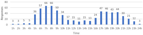
Figure 6. Rhythm and activity times of people at Pgs


This information would change the way that architects, urban planners, and authorities understand and manage these places. The landscape design project must consider this rhythm to adapt and better answer the utilities of citizens.
4.1.3. Biodiversity and Permeability, Exceptional Ecological Values of PFGs
PFGs in five central districts of Hanoi present a considerable ecological value in the urban context. A common vegetation structure for all PFGs has been found throughout the spatial data collected by the research project. There are, in general, three layers of plants: canopy trees 15–20 m tall, shrubs, and grass. This creates a distinct place with a biodiversity quality that differs from the high-density building spaces of Hanoi. Most PFGs have a large area covered with grass that is regularly trimmed. Although this form of coating has poor biodiversity value, it still provides an important permeable surface. These characteristics can be recognized clearly in Thanh Niên PFG. Vegetation is the most prominent ecological feature for the space of this PFG. With a morphology extending along Thanh Niên Street, the vegetation structure of this PFG also repeats along the axis with three layers of plants: canopy trees 15–20 m tall, shrubs, and grass at ground floor (Figure A2). The species of trees grown in the Thanh Niên PFG area are quite diverse, especially the canopy tree group, which not only improve the local ecosystem quality by enhancing the climate regulation and creating habitats for animals, but also by creating a harmonius and attractive landscape to enhance the urban spatial quality. Besides, the natural surface covered by vegetation occupies most of the total area of Thanh Niên PFG, helping to increase the water permeability capacity of the space. In urbanized basins, 10–20% more of the total surface is impervious to water than in forested basins, and this is found to be sufficient to double the surface runoff [2]. The permeable surface is therefore very important in urban flood management. Urbanization is a powerful driver of land surface transformation, with strong impacts on biodiversity, ecosystem functions, and infrastructures disasters. The diversity of plants and the high rate of permeable area at Thanh Niên PFG is of great value in improving green infrastructure to regulate floods and the environmental sustainability. Moreover, the sustainable existence of PFGs from their creation in Hanoi’s historic centre, where urbanization is constantly increasing, creates an exceptional value for Hanoi life quality. The current network of PFGs serves as a premise for expanding the vegetation greenness for the city, thereby increasing the abundance of vertebrates (mammals, birds, and amphibians), an important indicator of the biodiversity [46].
4.2. Community Participation in the Urban Landscape Design of PFG Thanh Niên: Effectiveness and Limit
4.2.1. An Experiment of Community Involvement at All Urban Landscape Design Steps
Interdisciplinary science and community involvement is increasingly being promoted as an effective approach to tackle sustainability issues [13]. In the case of urban design, stakeholders have different schemes of work, approaches, and perspectives. The question here is how these actors effectively combine and work together on the project. This collaboration needs to be carried out in a reasonable way to avoid unnecessary conflicts. The implementation and results of the research project showcase the potential of different roles of the community groups in different activities of landscape urban design.
In the first phase of the research project, residents acted primarily as the source of sociological data collection by responding to surveys. A large amount of information on a wide range of aspects was gathered, thanks to the active participation of respondents. At this step, the community expectations for additional utilities and equipment would be an important source information for the PFG renovation proposals. Community feedback on proposed designs in phase 2 also helped to identify relevant trends in society’s perception and expectations of urban design in relation to nature and surface water. Overall, this participation of the community helped to efficiently identify relevant characteristics and values of PFGs, giving interesting hints for the conceptualization of urban landscape designs.
A clear trend in the community’s opinion about renovating the existing space of Thanh Niên PFG is the addition of urban utilities and increasing the diversity of space usability. The survey results show a remarkable convergence of people’s attitudes towards decorative works, lighting equipment, amusement, and sports equipment in the PFG. The percentage of respondents who want an increase in the quantity and renewal of equipment is always over 45%, and the rate of those wishing to improve the quality of these urban equipment is over 30%. Only the numbers of recreational and sports equipment are partially meeting the needs of the people, as about 40% of the respondents said that they are satisfied with the current status (Table A1).
The community, as the end user of the PFGs, needs to be part of the approbation process of the design. The integration of community participation in this process is also in the spirit that has been mentioned in the official regulations on urban planning. The active participation of the community in the exhibition, where the presentation and selection of the Thanh Niên PFG design proposal was made in phase 2, showed the community’s willingness and readiness on this matter. It also brought a relevant input for design selection.
4.2.2. Discovery of Community Views on Changing the Approach to Water
-
Greater attractiveness of PFGs near surface water
The results of the first sociological survey in phase 1 confirmed a huge social demand for PFGs, especially for the ones with a connection to a water body. Across all surveyed PFGs, 49.8% of respondents answered that they go to the PFG every day, and 22.1% go there several times a week. But for the PFGs in the Tây Hồ district, where two of Hanoi’s largest urban lakes are located, West Lake and Trúc Bạch Lake, these values are 73.3% and 11.1%, respectively. The outstanding daily user rate shows the exceptional value where the water is part of the PFG’s attractiveness.
Another point worth noting is the attraction of PFGs with a relatively large impact radius, not only for residents living around them, but also for those living further away. With all surveyed PFGs, 23.4% of respondents live less than 0.5 km from the PFG, 60.4% of people live from 0.5–2 km away. The presence of water makes this radius even wider. For the Tây Hồ district, these two values are 13.3% and 75.6% respectively. Especially in the in-depth survey for the case of the Thanh Niên PFG in phase 2, up to 54.9% of people live more than 5 km away, 43.1% of people live within 0.5–5 km, and only 2% live less than 0.5 km away.
-
Potential for re-naturalizing water bound PFGs
Another interesting result from the survey in phase 2 is the gap between the current treatment of urban water and the community’s point of view.
Hardening water banks and soil surfaces is a dominant trend in urban waterfront development in Hanoi [47]. Almost all lakes in the city have been embanked, including West Lake, the largest lake in the city, with a circumference of more than 15 km. However, in the case of the Thanh Niên PFG, which is located right next to West Lake, more than two-thirds of people surveyed at step 4 think that the water bank here should be naturalized (Table 1). This demonstrates that the regeneration of wetland ecosystems is a socially viable approach to urban landscape design.
Table 1. Community points of view on how to design the Thanh Niên PFG in cohesion with West Lake.

The connection to water also differs between the current space design and the social perspective. Along with the hard embankment, most of the lakes in the city are equipped with railings, which prevent people from directly accessing the water surface. In the survey, 40.9% of the respondents said that this structure should be removed. As for the idea of building a stage overhanging the lake, up to 64% of people think it should be realized (Table 1). That suggests a change in approach to connecting to the water body. A new and bolder design is quite likely to receive a positive reception from the community.
4.2.3. Stakeholders’ Involvement, Public Awareness, and Social Acceptance of the Design
The implementation of the research project showcased the active participation of local stakeholders in all activities, from start to end. The sociological survey activities have received a positive response from the people. With the PFG Thanh Niên landscape design pilot project, local authorities participated in the sociological survey as respondents, and provided substantial logistical support to the project. During the exhibition of landscape design proposals, both residents and local authorities attended and showed great interest in the designs through their feedback. In this way, the project’s activities have been able to contribute to raising stakeholder awareness, not only about urban landscape design activities but also about their roles and capabilities.
In addition, the close involvement of local stakeholders in most of the research project’s activities, especially the recurrent interactions with the proposals in phase 2, ensures the feasibility and understanding of stakeholders of the final design. Design proposal 2—the winning one—suggested a large-scale urban wetland reconstruction across the entire West Lake. This solution could bring many benefits, but it must be determined that the re-naturalization of urban spaces is not a magic wand. In the short term, it can cause certain conflicts of interest among many parties, “providing improved state of water related ecosystem services and livelihood proposals for some, while potentially effective sources of income for others” [48]. However, the trend of long-term benefits when wetland reconstruction is carried out with care and associated ecosystem services has been confirmed by many cases around the world, “the economic and social benefits can be exceptionally high” [48]. The results of the community survey in phase 2 gave some confidence in this scenario. It should be noted that the feasibility of the selected proposal is also superior to that of the other two proposals. Firstly, it was the proposal that received the most votes, thereby becoming the chosen design for finalizing and making a technical dossier. In addition, the survey’s results also demonstrated the clear interest of the community in ecologically friendly solutions for urban landscape design, like bringing a closer connection to the water surface and nature. Finally, the technical and economic comparison analysis conducted at the end of phase 2 also showed that the second design proposal requires a reasonable level of investment while providing the most sustainable profit.
4.3. Potential for Urban BGI Development with Community Participation
4.3.1. Fragmentation in the Management of Blue and Green Spaces in Vietnam
The values of PFGs, as well as the potential conflict between designed spaces and the actual use of the people, have not been fully studied. Integrating those characteristics into urban design can also be limited because the current method of planning in Vietnam is highly technocratic. In urban projects, spaces are divided and labeled into categories of “land”. Both green space and surface water are collectively referred to as “land”, or “green land”, or “surface water land”. In fact, the green space and surface water in the urban area is implicitly understood as a kind of “reservation land” for construction, which can be mobilized when needed for urban development. Moreover, the results of the document analysis showed that the problems in state management with blue and green spaces are also reflected in the inconsistency in calculating the area of PFGs associated with lakes. With some PFGs such as the Hoàn Kiếm PFG, water is included in the garden area. But with the PFGs around West Lake, the management area is only encapsulated in the space of the garden. Thus, the actual interactions between components in the socio-ecological system, between natural factors and between natural and human factors, are often overlooked. In addition, the role of the end users of urban space—the people—is very weak in the planning and design process. Identifying these causes would help to improve the PFG management and better renovation of PFGs.
4.3.2. Potential for BGI Implementation in Hanoi
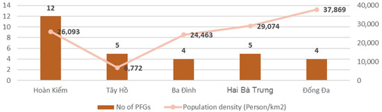
PFGs tend to be concentrated in the historic urban core area of the Hoàn Kiếm district (Figure 1), one of the most densely populated districts in Hanoi (26,093 people/km2). However, the density of PFGs is clearly not as high in some other districts that have simi-larly high population density, such as Hai Bà Trưng (29,074 people/km2), Ba Đình (24,463 people/km2), or even much higher, like Đống Đa (37,869 people/km2) [21]. The inconsistency in the number and area of PFGs with respect to population density (Figure 7) is because these PFGs were formed during the French colonial period and there have been no new PFG additions. Therefore, the network of these PFGs has not yet met the current urban development. Towards the orientation of a Green, Clean, Beautiful and Livable city, Hanoi City needs to invest in new green spaces in urban planning and development.
The results of the PFG project show the potential of linking urban design and BGI development in Hanoi, based on the surface water space and the PFG. Of the three design proposals, only proposal 2 has deeply developed the idea of an ecosystem with a combination of natural and man-made elements. The authors proposed to recreate a flooded ecosystem by renovating the structure of the water bank, transforming from a concrete embankment to a vegetated embankment (Table A3). This space not only creates a friendly place to welcome wildlife, but people can also approach the water closely by walking along the water bank. The authors even proposed to expand the scale of this structure along the banks of West Lake, not just limited to the area of Thanh Niên PFG (Figure 4). This bold idea suggests recreating a wetland in the heart of Hanoi, which was historically built on a large wetland. Wetland regeneration is known as a method of creating BGIs and providing nature-based solutions [11], which has been supported by the UN recently [48,49]. It offers many direct benefits in terms of water supply regulation, flood mitigation, water purification, and temperature control. By extension, it also provides ecological and social co-benefits such as enhanced biodiversity, recreational, aesthetic value, livelihood income possibilities, and climate change adaptation and mitigation [32,49].
5. Conclusions
This study analyzes data from a research project on PFGs in the five central districts of Hanoi, applying a combination of the landscape approach and the ULL approach, to qualify the values of PFGs as well as the potential of community involvement in urban landscape design activities. The results of the analysis reveal the specific characteristics of the PFGs in Hanoi Centre and the promising potential to establish BGIs based on these spaces. This is a dynamic public space, in close connection with the transformation of the city, with cultural–historical values as well as the activities of contemporary urban residents. The system of PFGs also offers special ecological values for a highly urbanized environment, which is a prerequisite for the establishment of urban BGIs. However, improvement in urban planning and design approaches might be needed to overcome the fragmentation and inconsistency issues in urban management of blue and green spaces in Vietnam. Community participation has demonstrated effectiveness in the urban landscape design process. On the one hand, community participation contributes directly to urban design outcomes through providing information and inspiration, as well as participating in voting. On the other hand, active community participation until the end of the research project allows the raising of public awareness and ensures the social acceptance of the final design, which is a major challenge to establish BGIs in the cities [12]. These results would contribute to improving the way architects and urban planners work on public projects primarily dedicated to the community.
Nevertheless, the findings primarily rely on field surveys conducted through experimental methods during a pilot activity. Thus, it is essential to subject the assumptions and assertions to further verification through more extensive spatial and temporal studies.
Author Contributions
Conceptualization, T.H.N.; Methodology, T.H.N.; Software, T.H.N.; Validation, T.H.N.; Formal analysis, T.H.N.; Investigation, T.H.N.; Resources, T.H.N.; Data curation, T.H.N.; Writing—original draft preparation, T.H.N.; Writing—review and editing, T.H.N. and D.O.; Visualization, T.H.N.; Supervision, T.H.N.; Project administration, T.H.N.; Funding acquisition, T.H.N. All authors have read and agreed to the published version of the manuscript.
Funding
This research was funded by the Department of Science and Technology, the Hanoi People’s Committee, 10000.
Data Availability Statement
Some data used in this study are available on request from the author.
Acknowledgments
The authors are grateful to Nguyen Tien Tam for his support in data accuration and representation. The authors also thank the Department of Science and Technology, the Hanoi People’s Committee, for funding the research project “Assessment of the current situation and propose solutions to organize landscape architecture of PFGs in the historic city centre of Hanoi with the community participation”. Thanks to the expert members from Hanoi Architectural University and the three teams of architects involved to the project.
Conflicts of Interest
The funders had no role in the design of the study; in the collection, analyses, or interpretation of data; in the writing of the manuscript; or in the decision to publish the results.
Appendix A
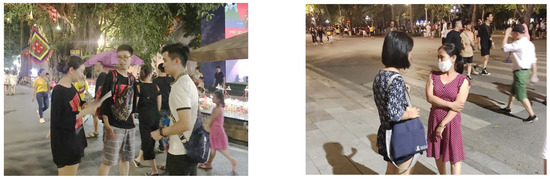
Figure A1. Performing surveys with people at PFGs.
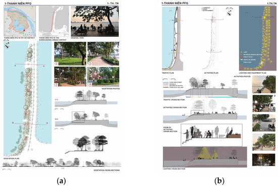
Figure A2. (a) Site vegetation analysis of Thanh Niên PFG; (b) Analyzing accessibility, utilization, and urban equipment of Thanh Niên PFG.
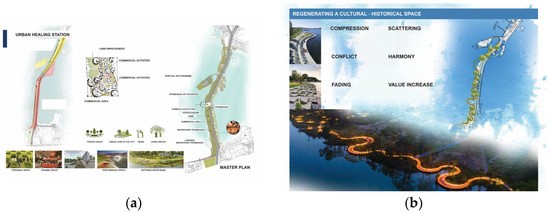
Figure A3. (a) Concept of landscape design proposal 1; (b) Concept of landscape design proposal 3.
Table A1. List of 30 PFGs in five central districts of Hanoi.

Table A2. Public view of decorative works, lighting, play, and fitness equipment in Thanh Niên PFG.
Table A3. Explanation of the nature-based concept of design proposal 2.
References
- Rockström, J.; Steffen, W.; Noone, K.; Persson, Å.; Chapin, F.S., III; Lambin, E.F.; Lenton, T.M.; Scheffer, M.; Folke, C.; Schellnhuber, H.J.; et al. A Safe Operating Space for Humanity. Nature 2009, 461, 472–475. [Google Scholar] [CrossRef] [PubMed]
- Alberti, M. Maintaining Ecological Integrity and Sustaining Ecosystem Function in Urban Areas. Curr. Opin. Environ. Sustain. 2010, 2, 178–184. [Google Scholar] [CrossRef]
- Norman, B. Are Autonomous Cities Our Urban Future? Nat. Commun. 2018, 9, 2111. [Google Scholar] [CrossRef] [PubMed]
- Anthopoulos, L.G. Understanding the Smart City Domain: A Literature Review. In Transforming City Governments for Successful Smart Cities; Public Administration and Information Technology, Rodríguez-Bolívar, M.P., Eds.; Springer International Publishing: Cham, Switzerland, 2015; pp. 9–21. ISBN 978-3-319-03167-5. [Google Scholar]
- Baccarne, B.; Schuurman, D.; Mechant, P.; De Marez, L. The Role of Urban Living Labs in a Smart City. In Proceedings of the XXV ISPIM Innovation Conference, Dublin, Ireland, 8–11 June 2014. [Google Scholar]
- Lachmund, J. The City as Ecosystem: Paul Duvigneaud and the Ecological Study of Brussels. In Spatializing the History of Ecology; Routledge: Oxfordshire, UK, 2017; ISBN 978-1-315-19104-1. [Google Scholar]
- Elmqvist, T.; Fragkias, M.; Goodness, J.; Güneralp, B.; Marcotullio, P.J.; McDonald, R.I.; Parnell, S.; Schewenius, M.; Sendstad, M.; Seto, K.C.; et al. Urbanization, Biodiversity and Ecosystem Services: Challenges and Opportunities: A Global Assessment; Springer: Amsterdam, The Netherlands, 2013; ISBN 978-94-007-7087-4. [Google Scholar]
- Odum, E.P. Ecology: A Bridge Between Science and Society; Sinauer Associates: Sunderland, MA, USA, 1997; ISBN 978-0-87893-630-4. [Google Scholar]
- Davasse, B. La Trace des Temps. Les Complexes Socio—Écologiques au Prisme du Paysage. Pour une Géographie de l’Environnement Impliquée. HDR Thesis, Université de Toulouse-Jean Jaurès, Toulouse, France, 2014. [Google Scholar]
- Cohen-Shacham, E.; Janzen, C.; Maginnis, S.; Walters, G. Nature-Based Solutions to Address Global Societal Challenges; IUCN: Gland, Switzerland, 2016; ISBN 978-2-8317-1812-5. [Google Scholar]
- Gerino, M.; Orange, D.; Sánchez-Pérez, J.M.; Buffan-Dubau, E.; Canovas, S.; Monfort, B.; Albasi, C.; Sauvage, S. What Inspiring Elements from Natural Services of Water Quality Regulation Could Be Applied to Water Management? Water 2022, 14, 3030. [Google Scholar] [CrossRef]
- Drosou, N.; Soetanto, R.; Hermawan, F.; Chmutina, K.; Bosher, L.; Hatmoko, J.U.D. Key Factors Influencing Wider Adoption of Blue–Green Infrastructure in Developing Cities. Water 2019, 11, 1234. [Google Scholar] [CrossRef]
- Rockström, J.; Bai, X.; deVries, B. Global Sustainability: The Challenge Ahead. Glob. Sustain. 2018, 1, e6. [Google Scholar] [CrossRef]
- Norström, A.; Dannenberg, A.; McCarney, G.; Milkoreit, M.; Diekert, F.; Engström, G.; Fishman, R.; Gars, J.; Kyriakopoolou, E.; Manoussi, V.; et al. Three Necessary Conditions for Establishing Effective Sustainable Development Goals in the Anthropocene. Ecol. Soc. 2014, 19, 1–8. [Google Scholar] [CrossRef]
- Lamond, J.; Everett, G. Sustainable Blue-Green Infrastructure: A Social Practice Approach to Understanding Community Preferences and Stewardship. Landsc. Urban Plan. 2019, 191, 103639. [Google Scholar] [CrossRef]
- Eriksson, M.; Niitamo, V.-P.; Kulkki, S. State-of-the-Art in Utilizing Living Labs Approach to User-Centric ICT Innovation—A European Approach. In Proceedings of the 4th International Conference on Management, Enterprise and Benchmarking (MEB 2006); Óbuda University, Keleti Faculty of Business and Management: Budapest, Hungary, 2005; 13. [Google Scholar]
- Puerari, E.; De Koning, J.I.J.C.; Von Wirth, T.; Karré, P.M.; Mulder, I.J.; Loorbach, D.A. Co-Creation Dynamics in Urban Living Labs. Sustainability 2018, 10, 1893. [Google Scholar] [CrossRef]
- Hossain, M.; Leminen, S.; Westerlund, M. A Systematic Review of Living Lab Literature. J. Clean. Prod. 2019, 213, 976–988. [Google Scholar] [CrossRef]
- Bulkeley, H.; Coenen, L.; Frantzeskaki, N.; Hartmann, C.; Kronsell, A.; Mai, L.; Marvin, S.; McCormick, K.; van Steenbergen, F.; Voytenko Palgan, Y. Urban Living Labs: Governing Urban Sustainability Transitions. Curr. Opin. Environ. Sustain. 2016, 22, 13–17. [Google Scholar] [CrossRef]
- Steen, K.; van Bueren, E. The Defining Characteristics of Urban Living Labs. Technol. Innov. Manag. Rev. 2017, 7, 21–33. [Google Scholar] [CrossRef]
- Chronéer, D.; Ståhlbröst, A.; Habibipour, A. Urban Living Labs: Towards an Integrated Understanding of Their Key Components. TIM Rev. 2019, 9, 50–62. [Google Scholar] [CrossRef]
- Ballon, P.; Schuurman, D. Living Labs: Concepts, Tools and Cases. Info 2015, 17, 13. [Google Scholar] [CrossRef]
- Dell’Era, C.; Landoni, P. Living Lab: A Methodology between User-Centred Design and Participatory Design. Creat. Innov. Manag. 2014, 23, 137–154. [Google Scholar] [CrossRef]
- Almirall, E.; Lee, M.; Wareham, J. Mapping Living Labs in the Landscape of Innovation Methodologies. Technol. Innov. Manag. Rev. 2012, 7, 12–18. [Google Scholar] [CrossRef]
- Kallai, T. State-of-the-Art in Utilizing Living Labs Approach to User-Centric ICT Innovation–Automotive, Rural, eEngineering and Renewable Energy LLs in Hungary. In Proceedings of the 4th International Conference on Management, Enterprise and Benchmarking (MEB 2006); Óbuda University, Keleti Faculty of Business and Management: Budapest, Hungary, 2005; 13p. [Google Scholar]
- Juujärvi, S; Pesso, K. Actor Roles in an Urban Living Lab: What Can We Learn from Suurpelto, Finland? Technol. Innov. Manag. Rev. 2013, 3, 22–27. [Google Scholar] [CrossRef]
- Veeckman, C. The City as Living Laboratory: Empowering Citizens with the Citadel Toolkit. Technol. Innov. Manag. Rev. 2015, 12, 6–17. [Google Scholar] [CrossRef]
- Nguyen, T.H.; Bui, T.T.N.; Le, P.A.; Nguyen, H.N.; Vincent, T. Sơn La, Vers la Ville Résiliente, Identité et Projets Urbains, Leçons d’un Atelier sur Site; Science and Technics Publishing House: Hanoi, Vietnam, 2022; ISBN 978-604-67-2343-1. [Google Scholar]
- Nguyen, T.H.; Dang, T.T. New Cooperative Approach between Universities and Enterprises, towards a Reality Urban Planning. Lesson Learnt from Nhon Ly, Quy Nhon City. In Proceedings of the CIGOS 2019, Innovation for Sustainable Infrastructure, Hanoi, Vietnam, 31 October–1 November 2019; Ha-Minh, C., Dao, D.V., Benboudjema, F., Derrible, S., Huynh, D.V.K., Tang, A.M., Eds.; Springer: Singapore, 2020; pp. 1117–1122. [Google Scholar]
- Nguyen, T.H.; Dang, T.T. “Living Lab”—An Urban Design Approach with Community Participation. The Case Study of Quy Nhon, Vietnam. In Proceedings of the CIGOS 2021, Emerging Technologies and Applications for Green Infrastructure, Ha Long, Vietnam, 28–29 October 2021; Ha-Minh, C., Tang, A.M., Bui, T.Q., Vu, X.H., Huynh, D.V.K., Eds.; Springer: Singapore, 2022; pp. 1303–1311. [Google Scholar]
- Nguyen, T.H.; Experimental Urban Design Workshop in Hanoi, Vietnam, Innovations for Urban Space Production. Presented at the International Conference on Challenges for the NEXT Generation BUILT Environment, Bologna, Italy, 13 May 2022. Available online: https://next-built.org (accessed on 2 June 2023).
- Coutts, C.; Hahn, M. Green Infrastructure, Ecosystem Services, and Human Health. Int. J. Environ. Res. Public Health 2015, 12, 9768–9798. [Google Scholar] [CrossRef]
- Hanoi People’s Committee QĐ Về Việc Phê Duyệt QH Hệ Thống Cây Xanh, Công Viên, Vườn Hoa Và Hồ Thành Phố Hà Nội Đến Năm 2030, Tầm Nhìn Đến Năm 2050 (Decision on Approving the Master Plan for the System of Trees, Parks, Flower Gardens and Lakes in Hanoi City to 2030, Vision to 2050). 2014. Available online: https://vanban.hanoi.gov.vn/c/document_library/get_file?p_l_id=Cms_WAR_Cmsportlet_INSTANCE_ARVabrfGV6T6&fileEntryId=2622859 (accessed on 2 June 2023).
- Soemardiono, B.; Rachmawati, M. The Innovative Landscape Design on the Old Dense Area Based on Community Participation. IOP Conf. Ser. Earth Environ. Sci. 2018, 126, 012192. [Google Scholar] [CrossRef]
- Le, Q.; Nguyen, T.H. Tổ chức không gian kiến trúc cảnh quan vuờn hoa công cộng trong khu nội đô lịch sử Hà Nội (Organizing landscape architecture of public flower gardens in Hanoi historic center). Tạp Chí Kiến Trúc (Archit. J.) 2021, 67–70. [Google Scholar]
- Holden, R.; Liversedge, J. Landscape Architecture: An Introduction; Laurence King Publishing: London, UK, 2014; ISBN 978-1-78067-270-0. [Google Scholar]
- Conseil de l’Europe. European Landscape Convention; Council of Europe: Strasbourg, France, 2000; Volume 176, p. 7. [Google Scholar]
- Arts, B.; Buizer, M.; Horlings, L.; Ingram, V.; van Oosten, C.; Opdam, P. Landscape Approaches: A State-of-the-Art Review. Annu. Rev. Environ. Resour. 2017, 42, 439–463. [Google Scholar] [CrossRef]
- Theys, J. L’approche territoriale du “développement durable”, condition d’une prise en compte de sa dimension sociale. Dév. Dur. Territ. Écon. Géograph. Polit. Droit Sociol. 2002. [Google Scholar] [CrossRef]
- Nguyen, T.H.; Viraj, C.; Bui, T.T.N. Colour Triology in Landscape Design; Science and Technics Publishing House: Hanoi, Vietnam, 2022; ISBN 978-6-04662-189-5. [Google Scholar]
- Kaymaz, I. Urban Landscapes and Identity. In Advances in Landscape Architecture; IntechOpen: London, UK, 2013. [Google Scholar] [CrossRef]
- Gottwald, S.; Stedman, R.C. Preserving Ones Meaningful Place or Not? Understanding Environmental Stewardship Behaviour in River Landscapes. Landsc. Urban Plan. 2020, 198, 103778. [Google Scholar] [CrossRef]
- Ziyaee, M. Assessment of Urban Identity through a Matrix of Cultural Landscapes. Cities 2018, 74, 21–31. [Google Scholar] [CrossRef]
- Nguyen, T.H. Applying the Urban Living Lab Model in the Conservation Planning of Nhon Ly Fishing Village, Quy Nhon. In Proceedings of the Polish-Vietnamese Experience in Preservation and Conservation of Architectural Heritage, Hanoi, Vietnam, 11–12 October 2021; ISBN 978-604-67-2106-2. [Google Scholar]
- Millennium Ecosystem Assessment (MEA). Ecosystems and Human Well-Being: Synthesis, 1st ed.; Island Press: Washington, DC, USA, 2005; ISBN 978-1-59726-040-4. [Google Scholar]
- Cai, D.; Fraedrich, K.; Guan, Y.; Guo, S.; Zhang, C.; Carvalho, L.M.V.; Zhu, X. Causality of Biodiversity Loss: Climate, Vegetation, and Urbanization in China and America. Sensors 2019, 19, 4499. [Google Scholar] [CrossRef] [PubMed]
- Nguyen, T.T.; Davasse, B.; Nguyen, T.H. Paysage de l’eau et politiques de (ré)aménagement dans le delta du fleuve Rouge. Proj. Paysage. Rev. Sci. Concept. l’Aménag. l’Espace 2019, 21, 21. [Google Scholar] [CrossRef]
- Bertule, M.; Lloyd, G.J.; Korsgaard, L.; Dalton, J.; Welling, R.; Barchiesi, S.; Smith, M.; Opperman, J.; Gray, E.; Gartner, T.; et al. Green Infrastructure Guide for Water Management. Ecosystem-Based Management Approaches for Water-Related Infrastructure Projects; United Nations Environment Programme: Nairobi, Kenya, 2014; ISBN 978-92-807-3404-1. [Google Scholar]
- International Union for Conservation of Nature (IUCN). Nature Based Solutions for Societal Needs—A Standardised Approach for Design and Verification of Interventions; IUCN: Gland, Switzerland, 2016; p. 45. [Google Scholar]